A Familiar Mystery Takes Flight Again
Randigo LLC 2025 investigation “Update” – In early 2024, low-flying aircraft flashing green lasers sparked concern from Florida to Massachusetts. At the heart of those sightings stood a Delaware-registered company few had ever heard of—Randigo LLC.
Eighteen months later, the mystery hasn’t faded—it’s evolved. New evidence from 2025 includes a fresh plane crash, confirmed LiDAR mapping missions, and ongoing silence from authorities. Randigo’s name now appears in federal crash reports, state filings, and eyewitness logs—yet the purpose of its nocturnal flights remains unclear.
2. The 2025 Tullahoma Crash: A Close Call That Raised New Questions
On June 8, 2025, a De Havilland DHC-6 Twin Otter (tail number N166DH) registered to Randigo LLC crashed at Tullahoma Regional Airport in Tennessee after an aborted takeoff.
The plane, operated under Skydive Tennessee—an affiliate of Revolution Flight, another company run by Paul Rossouw—was carrying 19 skydivers and a pilot.
Thankfully, all survived, though several suffered injuries.
The FAA and NTSB are still investigating the cause. It marks Randigo’s second crash since 2023, reigniting scrutiny over the company’s operations, safety oversight, and aircraft maintenance.
“It’s a miracle no one was killed,” local authorities said after the June crash. “But it highlights how little is known about these private operators flying daily over populated areas.”
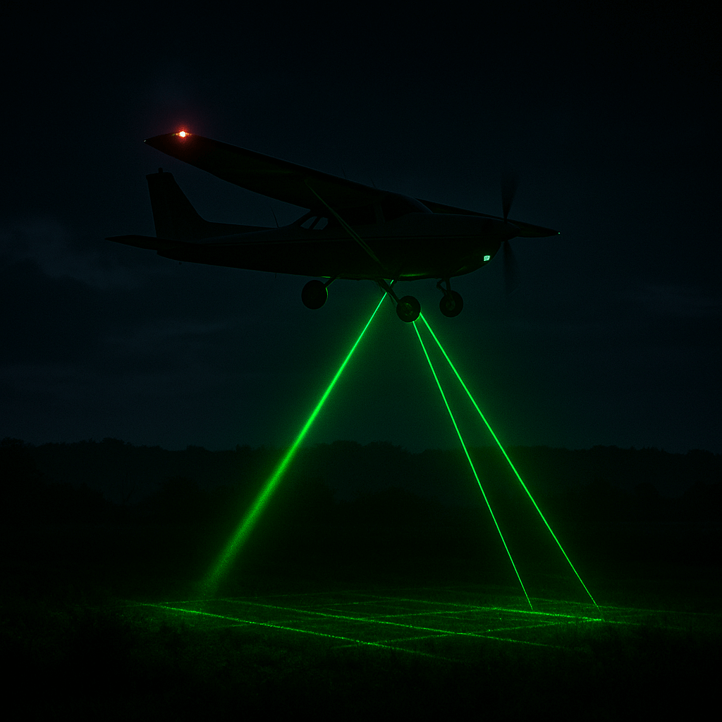
3. Confirmed Mapping Mission Over Virginia’s New River
A breakthrough in understanding Randigo’s purpose came in late 2024, when residents in southwest Virginia spotted a plane flying tight grid patterns over the New River, emitting bright green laser flashes.
The aircraft, verified as Randigo-owned, was later confirmed by Paul Rossouw himself to be conducting LiDAR mapping for a “large engineering company.” However, he refused to name the contractor, citing confidentiality agreements.
Government bodies including the U.S. Geological Survey, Army Corps of Engineers, and NOAA all denied involvement—deepening the mystery.
Experts say the green light likely comes from bathymetric LiDAR, a technology used to map water depth and topography. But without transparency, speculation continues about who funds and benefits from the data.
4. Fleet Overview: What FAA Records Reveal
The FAA Aircraft Registry confirms Randigo’s extensive and diverse fleet: over 30 aircraft, mainly Cessna and De Havilland models.
| Registration | Aircraft Type | Classification | Notes |
|---|---|---|---|
| N105RF | Cessna 208B Grand Caravan | Aerial Survey, Advertising, Agriculture | Active 2025 |
| N166DH | De Havilland DHC-6 Twin Otter | Parachute Ops / Survey | Crashed June 2025 |
| N369BB | Cessna 182T | Aerial Survey / Training | Crashed Dec 2023 |
| N119RF | Cessna 206H | Survey Operations | Active |
Randigo’s official FAA classification covers aerial surveying and photography, suggesting legitimate uses. However, its crossover with skydiving and tourism operations underlines a dual-purpose model—one that makes regulatory oversight harder to track.
5. Citizen Sleuths and Online Tracking
With authorities quiet, citizens have filled the gap:
- Reddit threads on r/flightradar24 regularly track Randigo’s grid-pattern flights, linking tail numbers to laser sightings.
- Facebook groups share real-time ADS-B screenshots, building a shared open-source record of each flight.
- Community logs indicate that many of these aircraft fly at altitudes below 5,000 feet, often repeating identical routes night after night.
This crowdsourced accountability has become essential. It shows that even when corporate transparency fails, public vigilance can still shine a light on the unknown.
6. Regulatory Oversight and the Road Ahead
Following the Tullahoma crash, the NTSB and FAA have expanded their review of Randigo’s operations.
If investigators find patterns of safety violations or misuse of aerial waivers, new transparency requirements for private survey companies could follow.
Until then, the only consistent transparency comes from the public itself—through FOIA requests, ADS-B data, and open-source collaboration.
7. What Remains Unknown
Despite mounting data, the core mysteries remain:
- Who are Randigo’s clients and what are the true purposes of their surveys?
- Where is the collected LiDAR and imagery data stored or sold?
- How are these operations authorized to fly at low altitudes over homes?
- Are public funds or agencies indirectly contracting Randigo through third-party firms?
Each answer seems hidden behind another layer of corporate anonymity—a puzzle built for persistence.
8. How Citizens Can Continue the Investigation
- Track Flights: Use ADS-B Exchange or FlightAware to log aircraft linked to Randigo LLC.
- Request Records: File FOIA requests via the FAA FOIA Portal.
- Collaborate: Join aviation and watchdog communities on Reddit and Facebook.
- Push for Oversight: Contact state aviation boards and representatives to demand clarity on private aerial data collection
9. Conclusion: Still Flying Below the Radar
As of October 2025, Randigo LLC remains both visible and invisible—its aircraft trace luminous grids across the night sky while its true objectives stay grounded in secrecy.
Between crashes, contracts cloaked in NDAs, and the green glow of unanswered questions, Randigo represents a growing dilemma of the modern age: the collision between technology, privacy, and accountability.
Until transparency catches up with innovation, citizens will keep looking up—watching the skies, and wondering who’s watching back.
Sources
- AVweb: “Four Hurt in Twin Otter Jump Plane Crash” (June 2025)
- WGN Radio: “Federal Investigators Probe Two Middle Tennessee Plane Crashes” (June 2025)
- WVTF News: “Mysterious Plane with Green Lights Surveying the New River” (Nov 2024)
- FAA Aircraft Registry (2025)
- ADS-B Exchange / FlightAware community logs
- Reddit r/flightradar24 & Facebook aviation watchdog groups
1 thought on “Randigo LLC: New Crashes, Confirmed LiDAR Operations, and Ongoing Secrecy in 2025”
Comments are closed.